Many Displaced from Hurricane Laura Are Now in Path of Hurricane Delta
Mobility data reveals trends of displacement between two major storms.
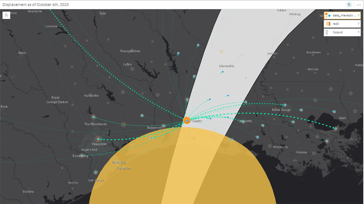
 Data from Facebook Data for Good shows the long-term displacement pattern for people impacted by Hurricane Laura, in relation to the likely path of Hurricane Delta.
Hurricane Delta is set to make landfall as a Category 2 storm on the coast of Louisiana and western Mississippi on Friday, Oct. 9. This would be a serious situation under any circumstance, but for those still displaced from the last major storm in this area, Hurricane Laura, which made landfall on Aug. 26, the impact is likely to be doubly hard. According to the best available estimates roughly 8,000 homes were damaged during the impact of Hurricane Laura, and many people have yet to return.
According to data from Facebook Data for Good, as of Oct. 6, there were at least 2,600 people still displaced from Calcasieu Parish, home to the city of Lake Charles, which bore the brunt of Hurricane Laura. That number equals close to 2% of the total population of the Parish, with true numbers likely being somewhat higher than the Facebook sample alone indicates.
The current displacement totals are improvement of more than 33% since the 20th of September, meaning nearly 100 people per day in the Facebook sample have been returning to their homes. However, with a second storm bearing down on them their return to any sense of normalcy may be significantly delayed.

The geographic spread of displacement from Hurricane Laura was very wide, with individuals dispersing from New Orleans, Louisiana, in the east, all the way to Dallas, Texas, in the west. The most common destinations apart from those two cities included Baton Rouge and Lafayette in Louisiana, as well as Jefferson, Beaumont, and Houston in Texas. Although Texas is not expected to see much impact from Hurricane Delta, many areas of coastal and central Louisiana are expected to see major wind and water damages.
Of particular concern may be a set of smaller parishes to the north of Lake Charles, including Vernon, Allen, Rapides, Evangeline, and St. Landry, which hosted a significant number of displaced persons in the aftermath of Hurricane Laura and which find themselves once again directly within the uncertainty cone for Delta.
This is also a relatively poor and socially vulnerable part of Louisiana, with roughly 45% of households reporting an income under $35,000 annually.
The national shelter system is reporting that the four shelters currently open for Hurricane Delta are located entirely within this inland area to the north of Calcasieu. However, recent data from the national shelter system throughout the Gulf shows that shelter occupancy rates remain very low relative to historical trends for similar events, with peak occupancy for Hurricane Laura topping out at only a few hundred individuals, as opposed to a baseline expectation of several thousand.
Many individuals who would otherwise have been housed in shelters have been housed in hotels, although given the duration of their displacement these alternate shelter arrangements may themselves be stretched to the limits.